The best hikes in Tenerife
Tenerife’s hiking trails attract millions of visitors every year. The island is famous for its scenery and, more than any of the other Canary Islands, walking seems to be one of the main activities. With hundreds if not thousands of routes to try, we were obviously limited in how many we were able to explore in the space of three weeks... But we gave it a good go!

It’s worth noting that Tenerife experiences a high level of emergency call-outs to its hiking routes. The holiday island isn’t thought of as a dangerous place, and relaxed tourists come unprepared for the rugged, steep, and difficult terrain that you’ll experience on many of the hikes here. The ravines (or barrancos) are incredibly deep in some places, and it’s easy to trip and fall if you’re not dressed appropriately.
Wear sturdy trainers or boots, never flip flops, and pack layers as once you’re high up you’ll find it’s much, much colder than it is at the coast. Find out more about what to pack for holiday to Tenerife here.
You should also bring at least 2L water per person, plenty of snacks, and a first aid kit on your hikes in Tenerife. You don’t want to become one of the hundreds of people responsible for emergency search and rescue teams that are deployed each year in Tenerife.
But don’t let this put you off! As long as you’re prepared, there are plenty of stunning hikes that you can experience safely and easily. These were our favourite hikes in Tenerife.
Pico Verde
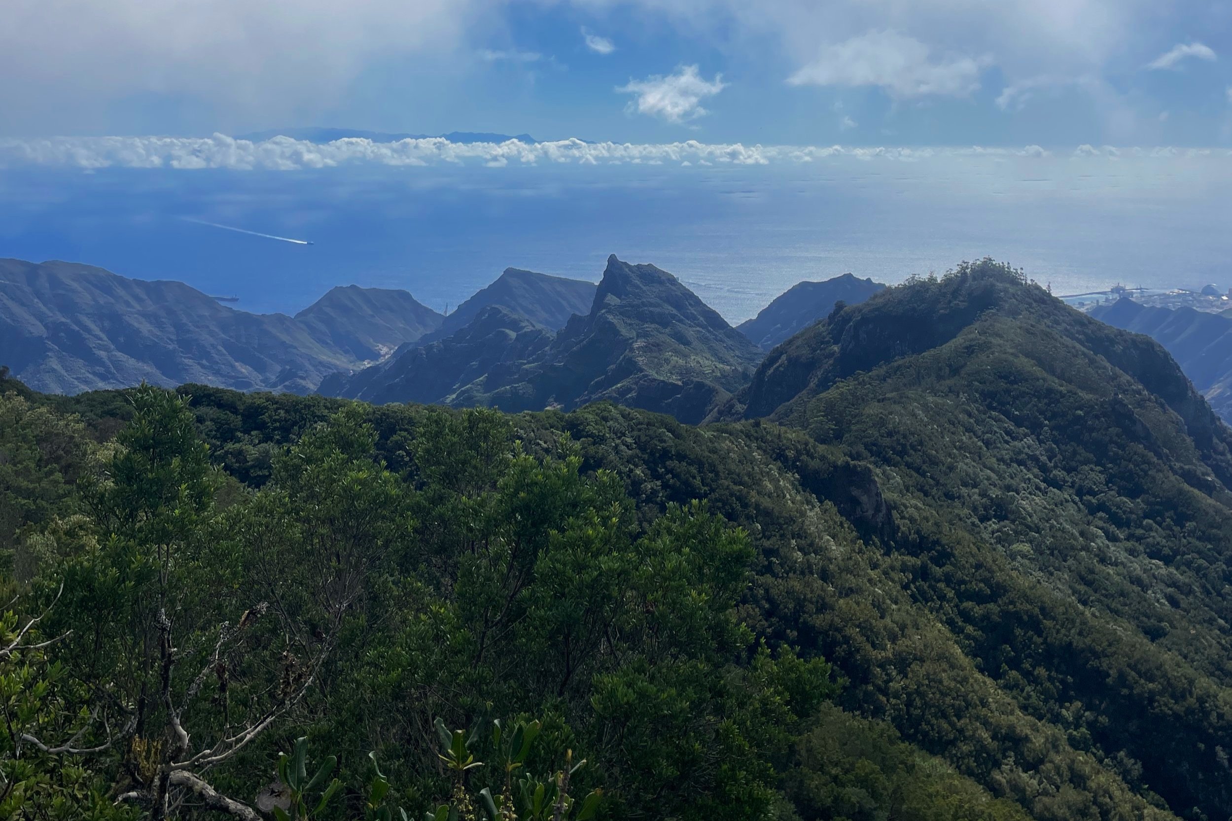
One of the most famous hiking areas in Tenerife is Masca. This tiny, remote village is accessed along winding roads and is known to have very little parking space while attracting millions of visitors per year. In fact, Tenerife is imposing fees to visit Masca as too many people are going to the area and inexperienced hikers are causing an increase in the amount of emergency rescues that need to be carried out in this remote and dangerous area.
So in favour of taking the path less travelled, we hiked to Pico Verde. Just north of Santiago del Tiede in Parque Rural de Teno, this hike takes you over the top of Masca so you do still get to enjoy an impressive view of the village. In fact, some of this route follows the same path as the popular one-way trail from Masca to Santiago del Tiede but with the benefit of being a circular route.
This hike took us through fields, pine and laurel forests, up a steep (but safe) cliff and along some stunning trails. It took us 2 hours 15 minutes to cover 8.73km (including photo stops, lunch, and going a little bit wrong at one point!) so it’s not a super strenuous hike and it’s easy with the exception of a couple of steep inclines. We parked outside Restaurante Fleytas, which is a great place to stop for lunch before or after your hike.
Samara

The Samara hike is an epic trail in the Mount Teide National Park. We completed this hike in cloudy weather and due to the elevation, we were much colder and needed far more layers than we had down in Puerto de Santiago that same morning. In fact, with the cloud cover and volcanic landscape some points of this hike felt like hiking through a black and white movie set. For almost all of this hike you can see Mount Teide in the background. It’s incredible, with some stunning red rocky areas and bright green trees that stand out even more impressively against the monochrome lava.
We completed the 9.83km route in 2.5 hours, including stops for photos and lunch. The elevation is very steep in some places with a total elevation gain of 435m. There is also limited parking at the start of this hike, so it’s best to arrive early especially during peak seasons.
Chinyero
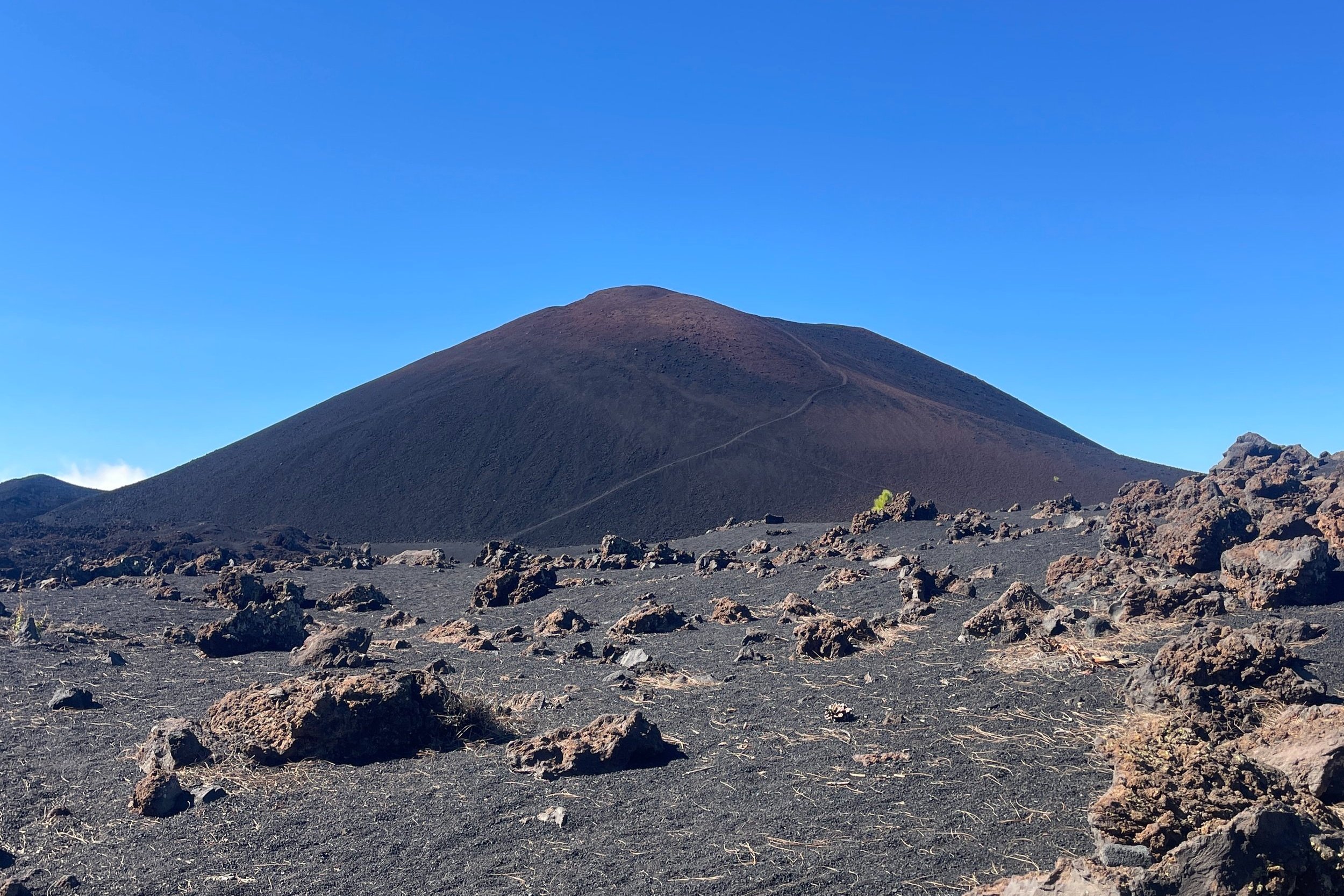
Chinyero volcano is close to both Parque Rural de Teno and Mount Teide National Park, and you can see the peak of Mount Teide for much of this hike. We decided to incorporate Montañas Negras into our loop, as the first circular route around Chinyero was very quick and easy.
You follow a gravel and lava path around the base of the volcano, on a route that is mostly exposed but does traverse some pine forest as well. We then continued north west to Montañas Negras, which added some elevation and new scenery to the hike, but it was still a safe and easy route.
Including photo and lunch stops, this double hike took us 3 hours 20 minutes, covering 12.33km. It’s easy to park at Arenas Negras car park, which is located in a pine forest and marks the starting points for a number of other hikes in this area.
Barranco del Infierno

If you’re avoiding Masca, Barranco del Infierno is a similar hike that is a little less busy and has the benefit of being an out-and-back route rather than one-way. Like the Masca Gorge hike, you will have to book and you will have to wear a hard hat throughout as you walk fairly deep into the gorge. It costs €13 per non-resident adult and slots start from 8am. Due to the heat, the closing time will vary.
When we visited in November, the last hiking slot began at 11:30am and the Barranco closed at 2pm meaning that all hikers had to be out by this time. This also means that the waterfall at the end of the route is closed with enough time to ensure that all hikers will make it back out before closing. So if you want to see the waterfall, book in for an earlier time to avoid disappointment.

Despite all the rules, this is a fairly easy hike. When you arrive, you’ll need to listen to a short safety brief before you set off, so arrive early. It’s not too steep, the path is very easy to follow, and though you’ll wear a helmet to protect you from falling rocks there are no other obvious dangers. We completed the 7.65km route in just under two hours (but be warned that your GPS tracker is likely to fail in the depth of the ravine).
There are plenty of parking areas in Adeje, including an underground car park that was fairly cheap for a few hours. But be prepared for a steep hike up from the town to the start of Barranco del Infierno. While you’re in town you could also check out the Santa Úrsula church and Casa Fuerte. There’s also a restaurant next door to Barranco del Infierno that’s open for lunch and dinner.
Montaña Roja
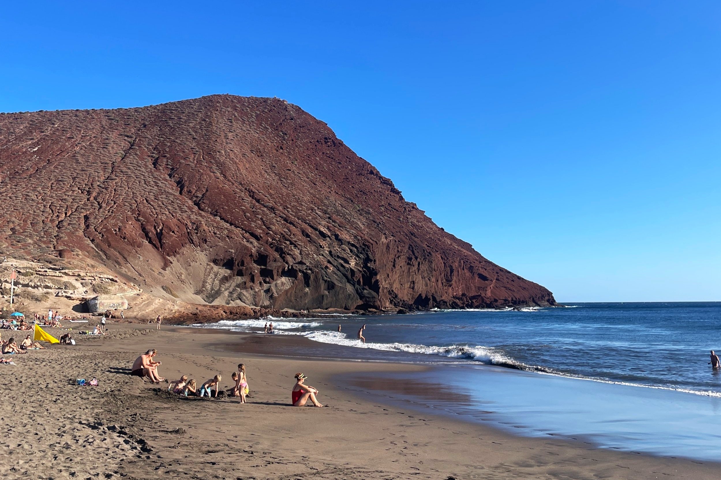
Probably the shortest but not necessarily the easiest hike we did in Tenerife was Montaña Roja. This is just west of El Medano and next to Playa Tejita which uses the same free parking area. From Montaña Roja you get a great view of the planes coming in and out of Tenerife Sud airport, as well as sweeping views of the ocean and nearby villages.
Though it’s not a long walk, it’s fairly steep so sensible shoes are advisable – although it’s tempting to head up in flip flops straight from the beach. The ground is rocky and can be slippery in places, but the trail is well marked and you’re unlikely to be the only walkers on the route. It took us just under 1 hour to complete this 3.07km out-and-back hike, including time taking in the view at the summit.
Other hikes

Some of the hikes we would have done if we’d had more time include:
Caserio los Partidos
Montana Guama (we actually attempted this but the Strava route took us very, very off-piste)
Paisaje Lunar hike
Anaga walk to Roque Taborno
Punta de Teno lighthouse
Barranco de Masca
Sendero de los Sentidos
More routes in Parque Rural de Teno